
On the Otter Trail - Hiking along the Coast of South Africa
The most famous hike in South Africa - the Otter Trail was as stunning as promised by the legions of hikers who have undertaken this flagship pilgrimage along the rugged Garden Route coastline. The trail traces the unspoilt coastline through the Tsitsikamma National Park section of the Garden Route National Park, starting at Storms River Mouth and ending at Nature's Valley to the west.
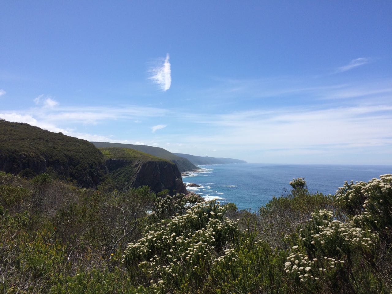
 Coastline
The Otter Trail Day-by-Day
The highlight of day one is the tiered waterfall which was bigger and prettier than we'd expected. The waterfall runs into a freshwater pool that flows directly into the crashing waves - an unusual sight. There are also nice rock pools along the way for refreshing dips.
 Waterfall landscape
The first day's walk is quite short, but parts are very rocky and we got our first taste of the steep ups and downs carrying our full backpacks. The two hikers sharing a hut with our party of four, decided to turn back at the end of the first day, after taking a few falls on the rocks and realising that they were ill-prepared. It was a shame to see them go, but they were carrying too much stuff and not equipped with the necessary gear or suitable food. Unfortunately they were not mentally and physically prepared either (particularly important for hikers over the age of 50), so they made a tough call and turned back.
.jpg) Day 1 Ngubu Hut by Travpacker.com
Day 1 Ngubu Hut by Travpacker.com
Day two was quite a long day filled with plenty of ascents and descents - notably the big hills at the start and end of the day. Tea on the rocky quartz outcrop of Skilderkrans was my highlight with the beautiful panoramic views over the ocean and coastline.
.jpg) Skilderkrans by Travpacker.com
Skilderkrans by Travpacker.com
We also enjoyed seeing interesting birds, insects and flowers amongst the tangled vines of the enchanting indigenous forest. The Scott Hut is a great spot for chilling out, watching the powerful waves crashing over the big rocks in the bay and walking along Geelhoutbos River.
 Crashing waves at hut
The Lottering River crossing was super easy and day three felt quite a bit shorter than the previous day (in part because our packs were getting lighter). Watching a big pod of dolphins surfing the waves and playing right in front of our overnight hut was the high point of the day!
 Day 3 Oakhurst hut by Travpacker.com
Day four was the longest and toughest day, as warned. We ran out of water, which was challenging and a little scary. By the end of the day we were dehydrated and more drained for it. Luckily we took rehydrate sachets which helped.
On day four you need to cross Bloukrans River at low tide, which means planning according to the tides. We had a choice between hiking to the river in the dark (about 10 km) in order to cross in the early morning hours, or waiting to cross in the early evening and then walking to the hut (about 4km) after dark. Having opted for the evening crossing we arrived at the river in the early afternoon, resigning ourselves to the five hour wait - without any water! Luckily the tide was low enough for us to cross slightly early so we avoided walking in the dark, which was a huge relief.
 Bloukrans River by Travpacker.com
The trail on either side of the river covers rocky terrain, sometimes with sheer drops into the pounding surf, which makes it challenging and difficult to follow at times (even in daylight). According to the official information the trail is well-marked and easy to follow along this section but we found it tricky and would not recommend doing this section in the dark. The final push (last straw) of the 13.8km hike on day four was the final climb onto the plateau and down to the hut at the end of a long day!
Day five - after a steep start to the day it was smooth sailing with the end in sight. We had a close encounter with a puff adder (dangerous venomous snake) but heard its warning hiss in time to back off and wait for it to move off slowly. The views on the final day were absolutely magnificent and we savoured our last bit of time in the dense forests and tall fynbos, away from civilisation.
 Otter Viewpoint
 View of Nature's Valley
Basics of the Otter Trail - About the Hike
Here are some of the questions commonly asked about the hike.
Duration - how many days does the Otter Trail take?
The Otter Trail entails five days of hiking along the spectacular southern coastline of South Africa. The first day can be done in about two hours and the last in about three, which means that you only need a half day at the beginning and end of the trail, if you are pressed for time. I would however recommend staying over the night before and after, giving yourself ample time to enjoy the scenery and rest after the walk.
TOP TIP: The Otter Trail reception area is located to the left of the entrance gate as you drive into Tsitsikamma National Park, not at the bottom of the hill at the main reception area. The entry gate is currently being revamped (upgraded if you will) resulting in a long queue at the gate, but hikers doing the Otter Trail do not have to wait and fill in extra paperwork. We waited, but could have headed straight to the trail's reception hut, if we had known.
Distance - how long is the Otter Trail?
In total the hike covers 42 km (26 miles) of uninhabited coastline. The distances covered vary from day to day with the shortest day (day 1) at only 4.8 km and the longest day (day 4) covering 13.8 km.
Terrain & Vegetation:
You trek through indigenous coastal forests and fynbos covered plateaus and valleys; across rivers and streams; and along rocky stretches and pebbled beaches. The topography is hilly, requiring trekking up (mostly) and down steep inclines, over and again. The Otter Trail may not be very long, but it steep descents and ascents make it more challenging than the relatively short distances suggest.
 Fynbos hill
 Minor river crossing
Accommodation on the Otter Trail:
The trail features wooden huts/cabins, which is fantastic because you don't need to carry tents and sleeping mattresses or go through the rigmarole of setting up and dismantling camp. Firewood is provided and the tap water is drinkable. On our first night the wood supply was very low, but for the rest of the hike there were good stock piles at the huts. On day four the water at the hut was very milky and formed bubbles on the surface, so we added aqua silver drops just in case. After the last hikers filled up their water bottles the following morning the water ran out - hopefully only temporarily.
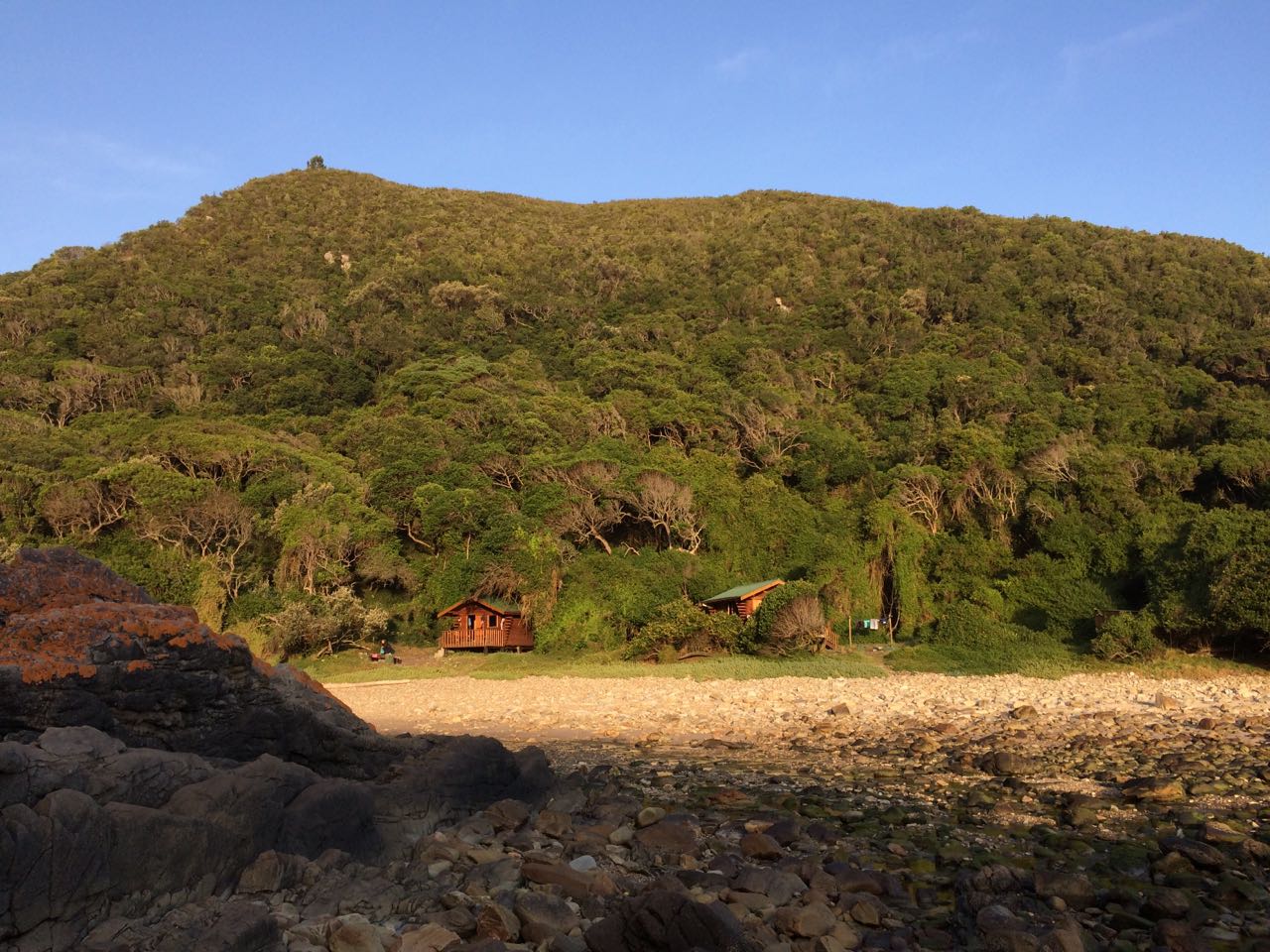 Huts on day two
The huts do not have electricity and the communal ablution facilities are shared between the two overnight huts at each stop. There is one toilet and one shower, with cold water (verrry refreshing) at the overnight huts. The toilets and showers have big one-way windows, mostly with great views over the ocean and coast.
 Hut view
The huts have two triple-levelled bunk beds with mattresses (sleeping 6), a counter for food preparation, hooks to hang stuff up and a couple of benches. Although the huts are basic, their scenic locations (right next to the sea or river mouth) make staying in them special.
 Hut inside
Is the hike age restricted?
You need to be over the age of 12 and under 65 to do the Otter Trail, due to the physically challenging nature of the hike. Don't worry, it's not as bad as it sounds - you need only be reasonably fit and well-prepared to complete the trail.
Is the Otter Trail safe?
The Otter Trail has an excellent safety record, but I will go into some detail because staying safe is central to any enjoyable hiking experience.
There are several emergency exit routes and access points for cell phone reception. Emergency numbers are provided at the beginning of the trail with the map and a detailed, illustrated booklet with useful information and a day-by-day breakdown of the hike. I took two power banks, in case we needed to charge cell phones to call for help (one should suffice). If you keep your phone on airplane mode and turn power saving on your phone might last for the whole five days, but I felt more comfortable with back-up power.
In my experience the main safety concern on the Otter Trail was - the puff adder that I came uncomfortably close to. Puff adders are slow moving which is both a good and a bad thing - depending on whether you have just spotted one or about to stand on one. They don't chase after you and attack you, if you come too close they warn you with a loud hissing/puffing sound - as I experienced. The safety advice is to wear closed shoes, keep a look out for snakes on the path and stay still when you encounter a snake, moving away slowly. If someone you are hiking with is bitten by a puff adder wrap stretch bandage (or similar) around the area of the bite in order to slow the movement of the poison through the lymph system. Try to keep the person as still and calm as possible, ideally getting them to sit or lie down, while someone else goes to get help. There are designated escape routes where you can get cell phone reception and reach the rangers.
The most common safety threat on the Otter Trail is the river crossing at Bloukrans River mouth, where hikers have been washed out to sea in the past. The advice is to cross no more than an hour before or after low tide. Rather wait until it is safe to cross and do not cross alone. Ensure that your backpack is in a waterproof bag so that it doesn't sink (or get all your stuff wet) and tie a rope to it, so that you can hold on. If the water level is too high (above waist level) and/or the current is too strong (pulling you off your feet) then rather wait or call the ranger station for assistance.
.jpg) Bloukrans River crossing by Rick McCharles
Bloukrans River crossing by Rick McCharles
Other safety risks to keep mind are: dehydration (take purification tablets in case, carry your own bottles for 2 litres and top up when you can) and getting lost (walk with at least one person and meet up with your group at set times or places during the day, keep your eye on the yellow markers, don't stray too far off the path and avoid walking in the dark if at all possible). Injury is the other main danger on the hike, so start walking early enough to avoid rushing or walking in the dark, and rest along the way, carry a first aid kit (preferably a basic one between every two hiking buddies), protect yourself from the elements to prevent sunstroke or overexposure by wearing the proper gear and drink water at regular intervals.
 Day two coastline by Travpacker.com
Price of the Otter Trail - how much does the hike cost?
The Otter Trail costs R1150 (at the time of writing), which includes the rustic cabin accommodation and firewood. This price does not include the daily conservation levies (about payable upon arrival. Wild Card holders don't have to pay the levies as the card gives you free access to the national park.
TOP TIP: Get a Wild Card.
Other expenses:
You need to factor in pre- and post accommodation, which adds to your expenses. We spent the night before the trail at the Nature's Valley Rest Camp where the cheapest hut was R510 per twin share unit. The hut was super simple but cute - a little wooden A-frame beside the river in the indigenous trees. The campsites only cost about R200, but it is really nice to have electricity, a comfy bed with bedding and a hot shower before and after roughing it on the trail.
The Nature's Valley Rest Camp accommodation rates do not include the daily conservation fees. We used our Wild Cards, which saved us the extra expense (one more reason to get a Wild Card). You can also stay in chalets, cottages or huts, or camp at Storm's River in the Tsitsikamma National Park, but you need to book in advance. Again, the conservation fees are not included in the accommodation tariffs.
Visit this page on Everything about The Otter Trail Hike, for a more detailed breakdown of the costs involved, including estimates for the hiking and camping equipment you will need.
Getting there & away:
Your best option is to fly into George or Port Elizabeth and hire a car (or two) for your group, or arrange a shuttle transfer. Because the trail ends in Nature's Valley you will need to leave a car at the end of the trail or book a shuttle back to the start at Storm's River if you left a car there.
Two of our group drove from Cape Town, a distance of about 560 km (around six and a half hours). Check out this blog post that goes into more details about preparing for the Otter Trail, including getting there and your transport options.
Hiking Advice for the Otter Trail - tips for doing the hike
1. Book in advance
You need to book this trail up to a year in advance. As one of the most scenic hikes on the planet, the Otter Trail is hugely popular. A group of 12 hikers sets off on the trail every day, but unless you get lucky and there are cancellations - the waiting time is still as long as a year.
The most important considerations for booking the trail are the tides and the season. Although the Garden Route (Storm's River and Nature's Valley included) receives rainfall throughout the year, it is more rainy in winter. If you are hiking the Otter Trail in winter, expect cooler temperatures and more rain.
TOP TIP: Book the Otter Trail for a period when low tide falls in the middle of the day or in the early afternoon for the Bloukrans River crossing on day four. This is ideal because you will avoid hiking in the dark and rushing, which is more dangerous.
You can check for availability and book the Otter Trail on the South African National Parks (SANParks) website, which accepts credit card payments. Alternatively you can call reservations ( +27 (0) 12 426 5111) or send an email.
2. Be physically prepared, but take it easy
Although you don't need to be super fit to do this trail - the fitter you are the more pleasant the experience. The distances covered are manageable, requiring a reasonable pace that allows for short rests, refreshment stops and swimming breaks. We took it slowly, hitting the trail early enough to leave time for appreciating the flora, fauna and awesome views as we walked.
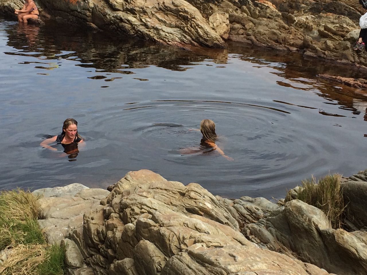 Swimming spot
You don't need to rush - the distances are doable, so enjoy the scenery and be careful. A moderate and steady pace will help avoid injuries and falls, which are surefire ways to ruin the hiking experience. Walking at a reasonable pace also conserves energy, enables you to move more quietly and see more animals and birds, as well as spotting snakes in good time.
What to Pack for the Otter Trail
Your main packing checklists fall into four categories: food and cooking, clothing, essentials and nice-to-haves.
My main advice is, of course, to pack light, but smart. The lighter each item the better so plastic and titanium items are usually preferable. Also, don't forget to share the load with your hiking buddies - one tube of toothpaste goes a long way.
.jpg) Skilderkrans view by Rick McCharles
Skilderkrans view by Rick McCharles
Our Top Five Things to Take on the Hike:
- The sarong/kakoi - the ultimate multi-functional item used as towel, head and shoulder scarf (sunshield or warmer), extra stuffing for the pillow or beach throw etc
- Head lamps - for cooking, washing and generally doing anything after dark at the huts. It is very important to take a head lamp (or torch) in case you end up walking after dark.
- Trekking poles - hugely helpful for the steep uphills and downhills (also for clearing cobwebs on the path etc).
- Sun hat - the sun is hot and some section are not shaded by trees, so take sunblock, hat and sunglasses.
- Rain gear - pack cover and rain jacket
Food & Cooking:
I took a light bowl and a spork (nifty fork, spoon and knife combo utensil), along with a small gas stove and set of nested titanium cooking pots. Handy tip: pack small plastic containers of salt, cooking oil, dish washing liquid, mixed herbs or chilli flakes and a little sponge/cloth for cleaning up, into the inner pot.
Don't go overboard with the food and leave the canned goods at home. You can carry meat for the first night or two on the trail as there are outdoor braai areas, but there is no electricity so don't take too much or hang onto it for too long (especially in the heat). I took too many boiled sweets (Sparkles are the best for hiking), but I craved healthier snacks. My top favourites included the boiled eggs we had on day one (could have lasted until day two), dried mango, nuts (trail mix), seed bars, pronutro bars (energy bars) and coffee, of course.
Rehydrate is excellent and light, so we were really glad we took some sachets. For us a morning coffee was a must and sipping on hot chocolate around the fire was fantastic.
Clothing:
- comfortable, worn-in walking shoes or hiking boots - my hiking boots are waterproof which is nice, but the most important aspect of your footwear is that your shoes fit well and are worn in properly. Some swear by trail running shoes with a broad base, because they are lightweight, durable and have excellent grip. I have hiking boots because its what I am used to, they fit my feet best, offer more protection (from sharp rocks etc) and provide ankle support.
- zip-off pants were really handy and water resistant
- pair of socks per day
- windproof rain jacket and sarong (as above)
Essentials:
- medical kit - stretch bandages, painkillers, plasters, imodium and antihistamines.
- water bottles/camel packs - carry at least 2 litres of water. Although there are numerous streams along the way, almost all of these were dry or tepid when we hiked (end of November). The map indicates plenty of natural places to top up on water, but drinking from the rivers is generally not recommended, particularly from the Kleinbos River on day two, which is considered unsafe.
- emergency numbers and maps
- sleeping bag - the lighter the better
- cooking equipment - gas stove, matches if necessary (our gas cooker ignites with the flick of a switch) and cooking pots
- dry sack (waterproof bag) for inside your pack to keep everything dry in this year-round rainfall area. My backpack is water resistant which helps, and I put just about everything into zip-lock bags because I didn't have a dry bag. This helps keep things dry but the ziplock bags turned the contents of my pack into a slippery mass of packets that I constantly had to open and reseal. Next time, I will be taking a dry sack, for sure.
- waterproof pack cover in case it rains (which it did) and for river crossings. One of our improvised waterproof covers (a plastic survival bag) got punctured during the crossing allowing water into the bottom. One of the back packs got wet soaking the sleeping bag, but luckily we had a spare sleeping bag liner and the conditions were dry and relatively warm.
Wish I had taken (nice-to-haves):
- a book or pack of cards for at the overnight huts.
- clothes pegs - we were very envious of the ladies in the other hut (five in a group of six) when they washed and hung up their sweaty items at the end of the day.
- just one more t-shirt - I would happily have carried the extra bit of weight for a fresh shirt by day four.
- milk powder (we could only get tea creamer which is not half as good).
- lightweight sandals for the river crossings (we had to use duct tape to keep our flip flops on when we crossed Bloukrans).
High-points of my Epic Otter Trail Hike
The tangled vines, oversized ferns and big old trees in the enchanting indigenous forests.
.jpg) Otter Trail forest by Rick McCharles
Otter Trail forest by Rick McCharles
Sweeping views of the rugged coastline and out over the deep blue Indian Ocean.
 View on Otter Trail
Swims in the sea and sleeping in huts right next to the crashing waves under starry skies. The dolphin pods playing in the surf in front of the hut and in the bay on day four.
 Sunset
The diverse flora (all kinds of vegetation - incredible little flowers and tall, aromatic fynbos) and fauna (genet, deer, agama lizards, birds and dassies).
 Fynbos
Greatest Challenges & Lows
- coming close to a puff adder on the path. Its hissing froze my blood on the spot!
- seeing rubbish along the way - just take a ziplock bag (or any old bag) and carry it to the next hut (each of which has a sign asking that hikers not litter and each featuring multiple bins with baboon proof lids)!
- running out of water on the longest, toughest day (day four)!
- getting sunburnt on the last day
- the steep downhills and uphills with big steps disappearing into the distance above... (trekking poles really do help)
 Steep hills by Travpacker.com
The Experience of Walking the Otter Trail
Walking along the towering cliffs and across the elevated plateaus covered in fynbos - I felt dwarfed and awed by the immense ocean with its savage waves and serene depths. The dense forests and untamed bush invigorated my senses as I breathed in the fresh sea air and the pure spaciousness of the open skies. My memories of pale pebbled beaches, gnarled drift wood pieces, limb-like trees, flickering fireflies and the movements of a shy genet at night are reason enough to motivate a rerun of the Otter Trail Hike. Gazing into the eyes of a quiet bushbuck in the early morning and watching the crashing waves at sunset, seeing frolicking dolphins in deserted bays - these are some of the countless marvels that make the Otter Trail experience so unforgettable.
 Otter Trail beach view by Travpacker.com
 Sunset
Useful Otter Trail resources online:
- Preparation for hiking the Otter Trail in South Africa - on Travpacker.com
- Blog with general info and recommended equipment for inexperienced hikers - Everything about The Otter Trail Hike
- An extensive packing list for the Otter Trail by veteran hiker, Gil Bauman, on the Getaway website.
- Beautiful photos of the Otter Trail by Chris Davies on the Getaway blog.
- The official SANParks Otter Trail page with general info, tariffs, reservations, availability and maps of the Otter Trail.
- An exceptional blog post all about the Otter Trail - The Definitive Otter Trail Guide by Alex Jordaan.
If you liked this post, these trips cover similar ground…
- South Africa Walking Safari to Kruger & Zululand
- 5 Day Cape Town, Garden Route & Addo Safari (Backpacking Tour)
- 6 Day Garden Route to Cape Town - South Africa Safari (Camping Overland Tour)
- Cape Town to Garden Route Tour - South Africa Safari
- 3 Day Greater Kruger Safari to Balule Big 5 Private Game Reserve
- 6 Day Climb Mount Meru - Tanzania Hiking Tour
 Landia is a nature and animal lover. This South African woman avoids crowds seeking out quiet places. She has worked in the African safari industry for over 16 years!

 Why not take a walk on the wild side in Southern Africa on your next trip?


