Use the Google map search to find most towns, suburbs and main roads within South Africa. View Street View on roads shown with a blue outline. The street viewer is beneath the map.
Street View is now available in South Africa and availability is indicated above by roads with blue outlines. The default view shown below is Chapmans Peak Drive, Cape Town. The viewer below will update to show a new street view when the map above is focused on an area where Street View is available.
Our Street Map of South Africa lets you zoom down to road map level (double click to zoom in, right double click to zoom out) , and is particularly detailed in major urban areas, like Cape Town, Johannesburg, Pretoria (Gauteng), Durban, Port Elizabeth, East London and so on. If you're travelling north of South Africa, some countries are quite well represented and our African road map is very detailed in places. There is good street level detail in countries as far north as Egypt although your mileage may vary for less well-travelled places.
Street View is now available in South Africa. Areas you can view at street level are designated by the blue outlines. Search for an address or zoom down to an appropriate level of detail and our Street Viewer will update to show the street view imagery beneath the map. Don't forget to scroll down to check out the street view beneath our map.
Use our road map of South Africa to plan your self-drive tour or budget city break . The map is also printable, so once you have the street map detail you want displaying, use your web browser to print it out and use on your journey. We'll be adding more map features and overlays soon to give you a more detailed picture of the distances and features to explore for your holiday in South Africa.
If you're looking to go on a road trip, check out our budget car hire options
Our safari travel blog covers all of the latest safari travel and conservation issues from Ethiopia to Cape Town
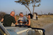
 Wajahat Mahmood (link)
So you're off on safari through the wild and vast plains of Africa? What safari vehicles can you expect to travel in? From overland trucks to safaris on foot, and everything between, here are the different types of African safari vehicles and best ways to explore Africa.
Read on
Wajahat Mahmood (link)
So you're off on safari through the wild and vast plains of Africa? What safari vehicles can you expect to travel in? From overland trucks to safaris on foot, and everything between, here are the different types of African safari vehicles and best ways to explore Africa.
Read on
 Self Drive Budget Safaris in South Africa give travellers the freedom to tailor their own experience, while taking the hassle out of planning everything and hunting for the best value accommodation and top attractions.
Read on
Self Drive Budget Safaris in South Africa give travellers the freedom to tailor their own experience, while taking the hassle out of planning everything and hunting for the best value accommodation and top attractions.
Read on